 With the summer quickly coming to an end, my wife and I decided to take a four day vacation in Mammoth Lakes, CA. This is a destination we had never been to before, although when we were teenagers we did make an abortive attempt to visit. In those pre-internet, teenage days our paper map was more misleading than helpful, and we ended up wandering about on the west side of the Sierras, looking for a nonexistent route that would take us to Devil’s Postpile National Monument – which sits on the east side of the Sierras – and on to the town of Mammoth Lakes. This time around, as middle-aged adults, we were wiser and equipped with Google Maps, so the 300 mile motorcycle ride unfolded smoothly and without too many confused meanderings.
Our route took us east on highway 4, through California’s Central Valley and Gold Country, over Tioga Pass in Yosemite National Park, and then south to Mammoth Lakes on highway 394. We followed a slightly more circuitous route on our return trip, adding another 100 miles in order to avoid too much backtracking. 400 miles is too much distance to cover during one day in the saddle, and by the end of the trip my rear end was bruised and sore. My wife was sore as well, but she avoided the lasting, visible damage that I incurred. I think I either need to travel fewer miles or get a pair of inflatable pants in order to continue these long distance rides.
 My bike is a 2005 Yamaha FZ1. The guys at the shop refer to it as “the last of the good FZ1’s” due to the fact that 2005 was the final year in which this particular model was carbureted. All models since have fuel-injection; a feature which I personally believe would be a benefit to me, since at high altitudes – like we experienced on our ride to Mammoth Lakes – my Yamaha has a tendency to hesitate during acceleration, making it necessary to vigorously rev the throttle in order to raise the engine’s rpms to avoid stalling. Fuel injection, as I understand it, would eliminate this problem.
Other than that issue, the FZ1 is a great bike. It has a 1000 cc inline four engine that is very powerful, making around 130 peak horsepower. It is relatively light and maneuverable, and despite my complaints about developing a sore butt during our latest trip, it is also quite comfortable for two-up riding. Just avoid super long distances in one go and you should be OK. I’ve modified the FZ1 with a 4 into 1 Yoshimura exhaust (complete with a new jet kit that also probably doesn’t help with high altitude performance), and a Corbin “Gunfighter” seat. I’ve replaced the sprockets, chain and various oil seals here and there. The only really major repair the motorcycle has required during its 50,000 mile life is replacement of the fuel pump. Overall, this is the most reliable bike I’ve ever owned. It has safely taken my wife and me on many memorable rides over the years, and although I have been looking for something new, it is with some feelings of hesitancy and regret that I consider selling the FZ1. I’m so used to this bike that I’m not really sure that I want to let it go.

The first leg of our trip took us on Highway 4. Running east/west between the SF Bay Area and the foothills of the Sierras, it is a route we found attractive mostly for its directness to our intended destination. There are a few interesting sights along the way, of course. Traveling through the Delta region, we passed over some picturesque bridges that span waterways cutting through the lush farmland of the western portion of the Central Valley. The smell of cow manure and chemical fertilizers hang in the air in these places, stirred up by the tractors that plow fields of crops while sending plumes of dirt and dust into the air. This, by the way, is why there is an elevated incidence of lung cancer in the Central Valley: particulate matter suspended in the air from farming.
The city of Stockton lies right between the Delta and the approach to the Sierra foothills. Stopping there long enough to get our bearings straight, we lingered in a neighborhood that was a cross between rural farmland and urban ghetto, parking beneath a sign that read “Vandals will be prosecuted.” There was a surveillance camera atop the sign, and as we looked over our map, a number of cars carrying young men drove past us, scrutinizing our presence. We felt like we might become victims of a drive-by shooting, so we rode over to a gas station where I tried to get directions. This, however, was the kind of place where: 1) Most of the people I tried to talk to ignored me, and 2) No one seemed to have any idea of what lay outside of the city limits. There was, finally, one young man who reassured me that we were probably headed in the right direction. Once we got around the detours and road construction that were causing us some confusion we would be headed roughly where we wanted to go. It turned out that he was right, and we eventually did find our way to Copperopolis, the first town marking our departure from the Central Valley and our entrance into California’s Gold Country.
 Imagine driving onto a movie set that is supposed to depict a small, clean American town and you will no doubt picture in your mind something like Copperopolis. As we exited the highway and entered the village, my wife and I thought at first that what we were looking at was a brand new suburban housing development. After stopping to fill up for gas and giving the place a closer look, however, it turns out that this was actually Copperopolis itself. Although originally founded in 1860, the town has been completely rebuilt from the ground up. As their website proudly states, this is “A whole new town with a historic past.” Tidy as a pin, and artificial as a movie set, Copperopolis consists of a nice little central square, complete with bandstand and gazebo, surrounded by brand new buildings fashioned in an old west style. As we rode around the downtown, we saw no people. The place looked abandoned except that there were sandwich board signs out in front of some of the businesses assuring visitors that they were open and operating. We passed by some restaurants, a day spa, an art store and an ice cream parlor. Honestly, it felt weird. I was reminded of the movie A Boy and His Dog, in which the main character finds himself held captive below ground in a comical yet menacing facimile of an all American town. To be fair, Copperopolis certainly feels safer than Stockton, and it sits in an ideal location to cater to visitors to Gold Country.
 Departing Copperopolis, we hit highway 49 and traveled south. The temperature had suddenly spiked to an almost unbearable degree, and so we stopped in Sonora for refreshments. Sonora is a charming old mining town, first established in 1848. Years ago, we spent a mini-vacation here, staying the night and attending a very lively karaoke performance put on by local singing talent. I still recall our amusement when listening to a long-haired redneck’s rendition of Aerosmith’s “Dream On,” during which he strained beyond his own abilities to hit the high notes of the vocal crescendo. There was also an older woman who sang Soft Cell’s “Tainted Love” in a flat monotone that was reminiscent of the Flying Lizards. This time around, we stopped at The Heart Rock Cafe downtown, right along Washington Street. Air conditioning, bagels and cold drinks energized us to continue our journey down highway 49 and then onto highway 120, which would take us through Yosemite National Park.
 Highway 120 is beautifully scenic, though arid at points. There is an ascent into the Sierras around Big Oak Flat that is quite spectacular. The road winds higher and higher, it becomes hotter and hotter, and the view of the scenery below becomes more and more panoramic. Other than the heat, the one annoyance of traveling this route is the fact of frequent traffic stoppages due to road maintenance. I’ve lost count of the number of times that we sat in the blazing heat for 1o or 15 minutes, waiting uncomfortably for the road to open so that an escort vehicle could lead us past construction areas. Regardless, the countryside is beautiful and once we reached the top of the winding rise at Big Oak Flat, it was a pretty straight shot through Groveland and on to the entrance to Yosemite.
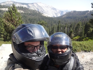
 The views from Highway 120 in Yosemite National Park are absolutely spectacular! What begins, from the west side, as a heavily forested road finally gives way, toward the east side, to breathtaking views of rocky peaks, alpine lakes and granite mountains. As we cruised at a leisurely pace along this road, I found myself overcome with a sense of ease and well being. Despite loads of tourists, the presence of this landscape transported me mentally into of a serene world where things are simple and uncomplicated, yet monumental and awe inspiring all at once. All I had to do was go on autopilot, maneuvering the motorcycle down the roadway, easing through curve after curve, while a vast valley of rock unfolded before my eyes. These formations, formed by millions of
  years of glacial activity, lay there, meaningless and uncaring. This is about as permanent as anything that I will ever experience in my lifetime. Here, I had the feeling of being in the presence of something bigger than myself. I suppose that’s the feeling religious people cherish; but while their God is beyond this world, mine is within it and made of stone. The Hindus claim that God, or Brahman, is “Thou before which all words recoil,” suggesting that the infinite nature of the Holy is something that human language is incapable of conveying. This is how I feel about the grandeur of Yosemite. Words cannot describe it.
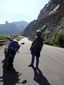 The descent through Tioga Pass, out of Yosemite and then south on highway 395 was the last leg of our journey to our final destination. This is a section of road that I had never traveled before. It is quite scenic, certainly, but in contrast to the views we had just witnessed, the long, straight, fast road made me more impatient for our arrival at Mammoth Lakes than anything else. Besides, my backside was definitely aching and my stomach growling.
The town of Mammoth Lakes is, I’ve heard, the single most popular destination for skiers in the US. During the summer months, it appears also to be extremely popular with mountain bikers, as the ski runs, devoid of snow, now become paths that are tackled by hundreds of two wheeled adventurers. The town reminds me of Lake Tahoe, with hotels and restaurants spread over a 25 square mile area that is surrounded by forests, mountains and lakes. So while you are, in a sense, amongst nature, you are not at all far from the buzz of civilization. Families with kids and tourists are in abundance. During our stay I consistently heard British, German and Japanese accents in the crowds of shoppers and restaurant patrons. There is a Starbucks. There is a Von’s grocery store. We stayed at the Westin Hotel in The Village, a small, central collection of hotels and shops that serves as a hub of activity near hiking trails and the entrance to Devil’s Postpile National Monument, which was to be the location of our first hike the following day.
After an excellent meal at Gomez’s, where my wife had fajitas and I had a really good fish dish called “Wahoo Mexicana” (which, incidentally was so good that I had it again the night before our departure), we walked around town a bit, only to discover that the 8,000 foot altitude was robbing us of oxygen. Yes, this is the high country, and you need to acclimate. Both my wife and I were huffing and puffing as we climbed the high flight of stairs to the hotel, and the next morning when I went for a swim in the hotel pool, my heart was pounding in my chest like pneumatic hammer.
On day two in Mammoth, we caught a bus from The Village to the Adventure Center, where we then boarded a park bus to go into Devil’s Postpile. Tourist information suggests that you take public transportation to the entrance of the national monument, but what they don’t tell you is that the town busses stop running at around 5pm, which was after the time that we finally came out of the park. Luckily, the park bus gathered up us few stragglers and gave us a lift back to town at the end of the day. Otherwise, we would have been facing a 5 mile hike back to the hotel.
Unless you have a permit to camp in the park, you are not allowed to bring in your personal vehicle, and so the park busses ferry hundreds of hikers into the valley each day. The ride is a bit unnerving, as the roads are little more than winding, single track fire lanes that are shared by full-sized busses going in opposite directions and piloted by drivers who seem very confident in their abilities to drive fast. Radio communications between busses alert them to oncoming vehicles along the way so that they don’t have unexpected encounters as they barrel up and down the steep and narrow roadways.
 Once off the bus, the hike out to Devil’s Postpile itself was short and easy. The postpile is a curious array of volcanic columns that, upon cooling, formed into regular, hexagonal basalt posts jutting out of the earth about 60 feet into the sky. They look artificial; as if extruded from the ground by a massive Playdough Fun Factory. Hiking up a trail to the side of the feature allows you to view the posts from the top. From this perspective they form a surface that looks like a tiled floor stretching to a cliff and sudden drop off. Though
  not on the spectacular scale of Yosemite’s natural wonders – like Half-Dome or El Capitan – Devil’s Postpile is amazing in its own way. Here you feel like you are peeking at a mere portion of the Earth’s inner power, frozen as it bursts through the crust. Standing at its base, I imagined traveling downwards, along the path of one of these posts, finally diving into a sea of molten rock at the center of the planet. Paff!
 From the postpile, it is about a 2 mile hike out to Rainbow Falls, an almost perfect, 100 foot high waterfall that cuts through a river canyon. The trail to the falls leads through a forest, much of which was burned by a massive fire in the 1990s, but which is now in the process of rejuvenation. The vistas are vast and well worth the exertion of the high altitude hike; although here, as in most places that we hiked, there is a veritable traffic jam of people on the trails.
 In order to avoid the rude surprise of a missed bus, on our second full day in Mammoth we took the motorcycle up Lake Mary Road in order to hike around Horseshoe Lake and then up to McLeod Lake. This region is studded with a variety of small lakes and sits at an altitude that allows for some wonderful views. One of the first surprises that greeted us were signs warning against swimming in the water or even sitting on the beaches. Apparently, during recent earthquakes, poisonous gasses were released from the ground, and they now seep up and collect in low lying areas, potentially causing anything from headaches to death! As testament to this hazard, there are swathes of dead trees near Horseshoe Lake that have been killed by exposure to the natural toxins. Despite all of this, the lake was filled with swimmers and kayakers, and the beaches were well populated with sunbathers and picnickers. I didn’t see any dead bodies, so either these people were lucky or the signs are a hoax.
 The highlight of the day was the hike out to McLeod Lake. Up a steep, forested rise, it sits less than a mile from Horseshoe Lake. Nestled among the trees, this small alpine lake was uncrowded and the waters were warm enough to dangle your feet in. Surrounded by mountains and silence as we sat on its shores, I could imagine that we were far away from civilization. This was perhaps the most relaxing part of our visit.
 After a good meal and a good night’s sleep, we mounted the FZ1 and headed back through Yosemite on our return trip to the Bay Area. Along with perhaps a thousand tourists, we took a quick detour down into Yosemite Valley in order to view some sights that we had not seen for many years: El Capitan, Half Dome, Yosemite Falls. The scene from this lower, valley level perspective really put me into a state of awe. Standing there, staring upwards, I felt very tiny. It was not just the fact that my body was so small in comparison to the rock formations towering above, but also my conception of the time frame over which these features had been formed. My own life, in comparison, is nothing but a blip on history’s radar screen. The granite that makes up El Capitan, on the other hand, is over 100 million years old. During the hundreds of years that people have been visiting this place, I’m just one of billions of human ants that have appeared and then disappeared, briefly standing in the shadows of this peak.
“Thou before which all words recoil.”

